By Victoria Webster, Ana Andries, Daniel Banks, Andrew Jamieson, Ben Siggery, Mike Waite, Richard Murphy, and Stephen Morse
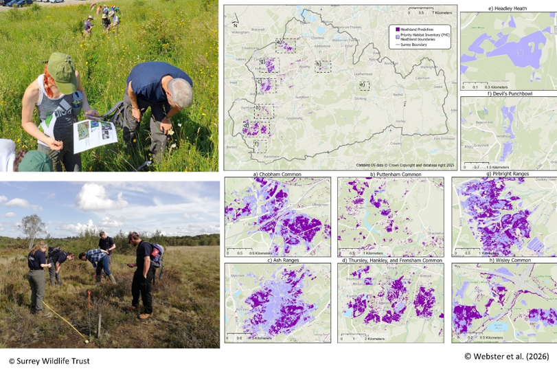
Nature in the UK is under pressure, and many important habitats are becoming smaller and more fragmented. To protect wildlife and restore nature, conservation organisations need accurate maps showing where important habitats still exist. However, collecting this information by walking across every site is slow, expensive, and often impossible across large areas.
In our research, we focused on one of the UK’s rarest habitats, lowland heathland, and explored a new way to map these habitats. Heathlands support many specialised plants and animals, including rare reptiles and birds. Instead of relying only on professional ecologists, we worked with citizen scientists—members of the public trained to identify key plant species and collect ecological information in the field. Volunteers carried out plant surveys across heathland sites in Surrey using a mobile survey app. Their observations helped us identify where heathland plants were present. We then combined these field records with satellite images and environmental information such as soil type and terrain. Using a computer model, we analysed these data to predict where heathland habitats are likely to be present across the whole county.
The result was a high-resolution habitat map showing potential heathland areas at a scale of three metres. The model performed well when tested with known locations of heathland, showing that citizen science data can help train reliable mapping tools. Importantly, the approach allows conservation organisations to update habitat maps more quickly and across larger areas than traditional surveys alone.
Our study shows that citizen science and satellite data can work together to support nature conservation. This method is transparent, relatively low-cost, and can be repeated in other regions or for other habitats. Involving volunteers directly in scientific research, it also strengthens public engagement with nature.
Better habitat maps help conservation groups decide where to focus restoration efforts and how to connect fragmented landscapes. Ultimately, approaches like this can support more effective planning for biodiversity recovery in the UK and beyond.
 Relational Thinking